June 7 – June 21, 2025
In 2024 we had a great time on the island of Pag (read more HERE). Over Pentecost, we returned to Croatia, 9A—this time to the beautiful islands of Cres and Lošinj, and the 2025 project: An Island is More Than IOTA launched.
🏝️ About Cres and Lošinj
The islands of Cres and Lošinj are located in the northern Adriatic, forming part of the Kvarner Gulf in Croatia. Once a single landmass, they are now separated by a narrow canal near the town of Osor, connected by a small swing bridge.
-
Cres is wild, quiet, and rugged—famous for its steep cliffs, pristine nature, fallow deers and rare griffon vultures. It’s ideal for hiking, solitude, and of course, SOTA and WWFF activations.
-
Lošinj, on the other hand, is livelier and greener, known for its pine forests, wellness tourism, and charming towns like Mali Lošinj and Veli Lošinj. With a slightly more developed infrastructure, it also offers great POTA opportunities and family-friendly beaches.
These islands is a true paradise for any outdoor ham radio operator. With over 35 XOTA references, Cres and Lošinj offer a wealth of opportunities. Since this was a family vacation, I aimed to keep all my radio activities family-friendly. That meant focusing on the XOTA programs I enjoy the most:
SOTA – 6 main island summits + 1 Plavnik island → ✅ 7 of 7 activated,
WWFF – 2 nature reserves → ✅ 2 of 2 activated,
POTA – 10 parks → ⚠️ only 3 of 10 activated.
Cres and Lošinj belong to the Croatia Kvarner Group, IOTA EU-136, and by default include WLOTA:
- Cres, island – IOCA CI-012, WLOTA LH-0553,
- Lošinj, island – IOCA CI-058, WLOTA LH-4295,
- Plavnik, island – IOCA CI-088, WLOTA LH-2344.
Any additional references were a pleasant bonus for the GMA triathlon. Whenever I could include MOTA, COTA, or LOTA references during my SOTA, WWFF, or POTA activations, I did so.
🌤️ Conditions & Equipment
The weather was fantastic the entire time! But the propagation conditions were weak and fickle. Nevertheless, even with QRP (4W), I managed 20+ QSOs per SOTA activation.
Learning from my 2024 experience on Pag island, I brought my low power station (running 20-40W) – and it turned out to be a great decision. The low power setup made the activations more enjoyable and effective.
Below is a summary of my activations and adventures, including a few unforgettable moments.
🏔️ SOTA Activations
June 9 – Velo Gračište (9A/PH-037, 562m)
A light family hike and a short QRP activation on a windy day:
✅ 23 QSOs on 40/20m in 30 minutes. Job as usual.
After activating Velo Gračište — junior SWLing to weak CW signs.
June 10 – Helm (9A/PH-042, 483m)
A spontaneous activation during a day trip to Lubinice with friends and family. I hiked ahead to set up early. At the summit, I was stunned to see a fishing pole with a SOTA flag! Who could it be? To my surprise, it was Frank, DJ2FR! I knew he had been on the island, but I thought he had already left.
After he wrapped up his activation, I plugged my QRP TRX into his antenna and logged ✅ 20 QSOs in 30 minutes. TNX, Frank! We chatted about HAMing, XOTA, islands, etc. and agreed to do a joint activation.
9A/DD1LD and 9A/DJ2FR on Helm, 9A/PH-042.
Both traveled hundreds of kilometers from home just to meet here by chance!
It turned out that we also lived in Cres close to each other on the island 😎.
There was a lot to discover on this beautiful family hike. The kids had a lot of fun.
June 11 – Gorice (9A/PH-034, 648m)
A solo morning activation with ✅ 33 QSOs (mostly on 40m) in 55 minutes.
Afterwards, I cheched Fojiška - Predošcica, 9AFF-0056 in: ✅ 63 QSOs (mostly 20m) in 1¾ hours.
Propagation was so poor, I skipped further radio haming that day😒.
On the way to Gorice. Great view to the south.
The view from the summit top was nowhere near as good as from here.
June 12 – Televrina (9A/PH-003, 588m)
The highest peak on Cres, jointly activated with Frank, DJ2FR.
✅ 44 QSOs on 40/30/20/17m in about 1 hour made with QRP.
We even enjoyed a brief early 17m opening. The other bands were also in good shape.
Great weather, great views, great company. Thanks again, Frank!
It was simply great to do a joint activation of Televrina with Frank, DJ2FR
and to exchange thoughts about our shared hobby.
June 14 – Zlostan (9A/PH-047, 428m)
A midday activation in hot weather, with ✅ 26 QSOs in 45 minutes.
Trail and summit were rather uneventful—job as usual.
On the way to Zlostan — take a rest, take a bath 😉😆.
June 17 – Grgoščak (9A/PH-058, 241m)
A drive-in activation with the family. ✅ 56 QSOs on 40/20m in just over 1 hour using low power. The family enjoyed the views while I operated. The highlight was an S2S QSO on 2 m with Daniel, 9A/DM1DF, who activated Zlostan, 9A/PH-047.
View from Grgoščak. There was much more going on Lošinj than on Cres island.
These two bays in the background are two of five bays with POTA references,
an ideal place for bay hopping by bike or boat. May be next time!?
June 19 – Krušija (9A/PH-061, 194m) – Real Adventure!
This one was epic. A real adventure!
Originally, Daniel, DM1DF and I wanted to charter a fishing boat from Merag to Plavnik Island. But due to rough seas, the trip was canceled. Once things calmed down, I decided to make the crossing solo on my stand-up paddleboard (SUP)!
Why Plavnik? This small uninhabited island between Cres and Krk is known for its secluded coves, wild goats, fallow deers, and dramatic cliffs. It’s remote, pristine, and totally off the tourist radar—making it a dream destination for adventurous ham radio operators (LOTA, IOTA/IOCA) and nature lovers alike. And, it has one SOTA reference — Krušija (9A/PH-061, 194m). This one was my real goal and this one was the hardest one pointer in my life!
The adventure began at noon. The starting point was the lonely beach Plaža Selzine. I hiked 100m down a steep trail to the beach, carried my radio gear in a waterproof bag, and paddled for 1.5 hours to Plavnik to reach Uvala Krušija. From there, I hiked 4 km in scorching heat to reach the summit.
At Uvala Krušija on Plavnik island. That's all I needed for a real ham radio adventure.
Island of Cres on the horizon in the background. A long and somewhat dangerous journey.
Despite tough conditions with deep QSB and limited time, I made ✅ 20 QSOs in 30 minutes. The return trip was challenging due to currents between the islands. I reached the beach at 19:30, completely exhausted but incredibly happy. I'm not sure if I want to do it again 😉.
APRS track of my adventure. 300m in altitude, 10km walking, and 12km paddling.
I'm back safe and sound after an adventure of about 7 hours.
Plavnik island in the background.
Looking back, I was very lucky with the calm weather window — it turned rough again shortly after.
🌿 WWFF – 9AFF Activations
June 15 - Mali Bok (9AFF-0057)
The second WWFF activation was at Mali Bok, 9AFF-0057:
✅ 84 QSOs on 20/30/40m in about 2 hours.
Tough propagation conditions. The stunning cliffside location made it a highlight.
My operating spot made my activation. View at Uvala Mali Bok 😍.
🏖️ POTA Fun on the Beach
Operating POTA on Cres and Lošinj is pure enjoyment. The island of Cres has two references: HR-0085 (Otok Cres Natura 2000) and HR-0026 (Kvarnerski otoci Natura 2000), and neighboring Lošinj offers at least one—HR-0226 .
I ran my station casually, often from the beach. If the bands died, or there were no takers, I’d take a break to swim, paddle, or play with the kids—then return to operating. That’s how POTA is meant to be!
Easy & lazy POTA operating from the beach.
LP vs. QRP - this is how you can endure the poor propagation conditions.
📻 Summary
This year’s ham radio activity in 9A was more
relaxed and enjoyable. The propagation
conditions were tough and changeable, however, there were
no total radio blackouts like last year on Pag island
(read more HERE).
Low power instead of QRP and
digital modes made radio haming more effective and dynamic, and
more fun!
CW has always been—and still is—my favorite mode. Operating SSB, especially with QRP, proved to be challenging: propagation conditions were weak and using a microphone on the beach was not always appropriate. So I kept experimenting with FTx, and I was surprised by the strong activity and demand in the digital modes.
✅ All SOTA and WWFF references were successfully activated.
⚠️ POTA was just for fun—and it was fun! And now I have a reason to come back: 7 POTA references still await!
As mentioned, all the other XOTA references (4x LOTA, 3x IOCA, 2x MOTA, 1x COTA activated) were a nice addition.
All in all: great weather, great time with the family & friends, beautiful nature, solid radio fun — and most importantly: No stress on Cres.
It doesn't take much to have a real adventure here. Finally, it's up to you — you have to create and conquer your own challenges! Cres is one of those islands you want to return to. And maybe I will, too. POTA bay hopping? IOCA (Islands Of Croatia Award) island hopping? Let's see.
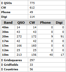
9A/DD1LD/P QSO Map. Almost all on 40m and 20m witn some rare DX.
9A/DD1LD/P statistics: CW - 57%, Phone - 11%, Digi - 32%.
41 DXCC on 20m.
Another Kilo Award from 9A ✅ remains a nice memory. TNX to all chasers!
TNX for reading — see you on the bands!
73 de Dzianis, DD1LD