One evening I got a call from a buddy of mine who asked if we could do a high alpine tour over a weekend together. Steffen wanted to hike the Roteck, 3337m (Monte Rosso in Italian) which is the highest peak in the Texel group of the Ötztal Alps. I needed a minute to take a close look at the map, and promptly answered with “Sure, with the greatest of pleasure!”
The initial plan was to start from Partschins towards Nasereith on Saturday in the early morning, take a rest at the Lodner Hütte, 2259m, climb the Roteck the same day, stay overnight at the Lodner Hütte and climb the Tschigat, 3001m on Sunday on the way back to Partschins via the Hochgangscharte. And the initial plan fell apart.
Saturday, July 7th, 2018
We started from the Birkenwald (930m) in the late morning and arrived at the Lodner Hütte after 12PM. Steffen got muscle cramps in the legs and proposed to climb the Roteck, 3337m, I/AA-020 on Sunday… Well, that is how it is. So, I switched to plan B – I still had plenty of time and a lot of energy to activate the Tschigat, 3001m, I/AA-331 and, eventually, the Spronser Rötelspitze, 2625m, I/AA-138. I told Steffen to expect me back before darkness covers everything and betook myself to the Halsljoch, 2808m.

On the way to the Tschigat, 3001m, I/AA-331. The weather got worse.
The Tablander See and Lazinser Rötelspitze, 3038m on the right.
 Approaching the Tschigat, 3001m, I/AA-331.
About 1.5 hours later I was approaching the Tschigat, I/AA-331. The weather changed suddenly, a cloudy mist hugged the summit like a child, and a cold wind started blowing from the north. The temperature dropped down, my iPhone I was carrying in a side pocket of my backpack suddenly died when it should still have some juice. I put all clothes I had with me on and was erecting an antenna just below the summit cross, as two guys arrived at the top. I explained my intentions and shared one headphone to listen to while calling CQ SOTA on 30 and 40m and occasionally chatting to them for the next 30 minutes. Neither the propagation conditions nor the time were optimal for activating, only 18 QSOs were logged. One of the guys lent me his power bank for about 10 minutes to bring my iPhone back to life. What a great spirit! So, I was able to put an alert for the upcoming activation of the Rötelspitze, I/AA-138 and send a message to my XYL, and even take a couple of pictures.
All three of us wanted to descend the Tschigat through a chimney on another side, towards the Milchsee, 2540m. There still were some steep snow fields, and we needed to slash our way through the chimney (UIAA II+). I followed the picturesque path to the Hochgangscharte passing the Milchsee and Langsee and had an easy climb to the Spronser Rötelspitze, I/AA-138.
 The Langsee on the way to the Spronser Rötelspitze, 2625m, I/AA-138. The weather got better.
The weather got better, the sun came out again but the cold wind was still blowing strong. I was QRV for about 30 minutes, the propagation on 40m and 20m was good enough to gather 18 QSOs plus 1 QSO on 30m.


The weather got better, the sun came out again but the cold wind was still blowing strong. I was QRV for about 30 minutes, the propagation on 40m and 20m was good enough to gather 18 QSOs plus 1 QSO on 30m.

I/DD1LD/P on the Spronser Rötelspitze, 2625m, I/AA-138.
 View from the Spronser Rötelspitze, 2625m, I/AA-138 towards the Spronser valley.

Being back to the Hochgangscharte, 2444m I made a fatal mistake. Following a recommendation from a local I decided to take way back to the Lodner Hütte through the Hochganghaus, 1839m following the Franz Huber path. Unfortunately, I had no detailed map of the area to check this suggestion. A much better choice would have been to go back via the Milchseescharte and Halsljoch. As soon as I arrived at the Hochganghaus at about 7PM I saw a trail sign that said “Lodner Hütte, 7B, 4 hours”. No way!? I had to be there before sunset, i.e. in about 2 hours latest.
I quickly informed the owner about my plan to approach the Lodner Hütte. The only one question she asked was “Still today?” I answered, “Yes, I must be there in two hours”. She just smiled back as I started running... running, hiking and climbing driven by fear of not having enough time and energy to make it in two hours. As I gained some height I was able to send a text message to my XYL with my actual coordinates and final destination before my iPhone finally died. There is no network coverage around the Lodner Hütte, so there was no chance to inform Steffen about my late arrival. Only when I saw the Lodner Hütte I caught my breath and calmed a bit down.
While approaching the Lodner Hütte I saw Steffen on the crossroad between 7 and 7B with a flashlight and binoculars looking for me. The Bergwacht (Mountain Search and Rescue Team) was already alarmed, however, they figured out very quickly that I was seen late in the evening at the Hochganghaus and should be on the way to the Lodner Hütte.
Finally, I made about 9km, up to the 2400m ASL again, a couple of cruxes with UIAA I/II in just two hours, just before dark. I felt totally exhausted after the 12 hours long hike and net elevation gain of about 2500m.
Sunday, July 8th, 2018
It was a typical night in the mountain lodge. We were woken up at about 6AM. Since Steffen needed/wanted to breakfast we started at about 7:30AM. We both were a bit tired, Steffen hiked the Blasiuszeiger, 2834m on Saturday in the afternoon. So, we wanted to take it easy today, and ascent remaining 1100m to the top without any time pressure. The way to the Roteck, I/AA-020 was a technically easy hike with only one serious crux (UIAA II+), however, with a lot of iron in the rock wall. Finally, we arrived at the summit cross in the sunshine and took a while to enjoy the greatest view and almost cloudless sky over the Texel group, and embrace the beauty of the Alps again… and again. The high Alps magically attract me, and unconsciously I started looking for the next summit I want to hike. I felt like the Hochwilde, 3482m with flat glaciers partly still covered by morning mist on the north side was calling me. So, bad!?

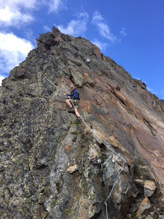

Dzianis on the way to the Roteck, 3337m.

Steffen mastering the crux on the way to the Roteck, 3337m.
I set-up my portable station close to the summit cross and made 30 QSOs in 30 minutes of operating time on 20, 30 and 40m. A good CQ run, however nothing exceptional. Then, packing, taking some pictures, making an entry into the summit book, chatting with others… enjoying every minute of being there.


I/DD1LD/P on the Roteck, 3337m, I/AA-020. The Hochwilde, OE/TI-706 in the back.
 3000er of the Texel Group: Hohe Weiße, Lodner, Lazinser Rötelspitze with Tschigat in the back.

View from the Roteck, 3337m, I/AA-020. The sky is getting cloudy.
It was time to descent, 2400m in altitude from the summit down to the parking spot had to be mastered. Two hours later we had light lunch at the Lodner Hütte, and another two hours later we were on the way back home, both tired and highly delighted.
In summary, 3 summits, 3 first activations, 2x 3000er, 67 QSOs and 3600m of net altitude gain were done.

In summary, 3 summits, 3 first activations, 2x 3000er, 67 QSOs and 3600m of net altitude gain were done.

Steffen and Dzianis in the dizzy heights. On the Roteck, 3337m, I/AA-020.
Some thoughts on operating high alpine SOTA
I wanted to know how strong my signs were. Something surprised me, e.g. from the Rötelspitze, AA-138 I worked Mario, DJ2MX in Munich on 40m with a solid 599(+) as if he were just around the corner (thanks Mario for recording), on the other hand I only managed one QSO on 30m; e.g. OK/OM3CUG/P sings (who was operating on OK/ZL-039) on 40 and 30m on the Tschigat, AA-331 were similar and just on the edge.
A simple evaluation of RBN I/DD1LD/P spots and number of made QSOs over the weekend might give alpine activators a sort of indication on which band(s) is(are) the best or optimal for operating QRP SOTA. The average of reported SNR, dB and the number of QSOs made on each band are summarized in the table below.
| RBN Band vs. SNR dB |
I/AA-020, Sunday, 08.07.2018, 8:50-9:20 UTC |
I/AA-331,
Saturday, 07.07.2018, 12:30-13:00 UTC |
I/AA-138, Saturday, 07.07.2018, 15:30-16:00 UTC |
| 20m | 6 | N/A | 8 |
| 30m | 8 | 11 | 10 |
| 40m | 14 | 11 | 13 |
| Band vs. QSOs | |||
| 20m | 9 | N/A | 8 |
| 30m | 9 | 6 | 1 |
| 40m | 12 | 12 | 10 |
| All bands | 30 | 18 | 19 |
The evaluation just confirmed my thoughts on operating high alpine SOTA:
- Although a 40m antenna usually has less efficiency and, usually, more weight compared to a 20m antenna, the 40m band should be your choice if you want to achieve a large number of EU chasers with QRP anytime in day or night. I think, on 40m you will maximize your chance of success.
- If you prefer to work DX chasers and don’t care much about the number of QSOs in your log, the 20m band should be your choice. You might design a ultralight and very compact however highly efficient single-band antenna for 20m, e.g. ~5m long GPA directly connected to your TRX (I mean, without ATU).
- Band switching, tuning and spotting cost some time. Operating on two bands only – 40/30m or 40/20m – seems to be optimal to me with regard to Number_of_QSOs/Operating_Time.
I tend to try out the option 2 where the overall set-up is optimized for 20m but I still can use fixed-tuned 40m aerial (with poor efficiency and sharp SWR curve) as a backup option. Any thoughts?
73 de Dzianis, DD1LD